🔆 India Adds 3,582 km to Coastline & 7 New Islands
📍A new reassessment using improved tech has increased India’s official coastline length by ~50%
✅ Previous coastline (1970s): 7,516 km
✅ New official length: 11,058.6 km
✅ Reason: Higher-resolution data (1:25000 map scale vs older 1:45000)
✅ 3,582 km “added” due to better capture of curves, bends & offshore island coastlines
✅ 7 new offshore islands identified; total island count now 1,389 (1,298 offshore + 91 inshore)
✅ Coastline measurement now to be done every 10 years
📍State-wise highest coastline
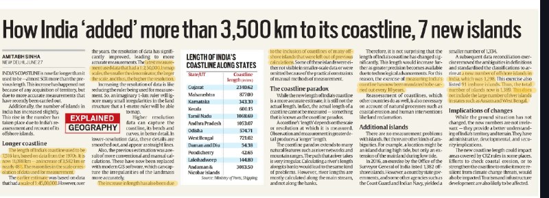
✅ Gujarat (2,340 km), Andaman & Nicobar (3,083 km), Tamil Nadu (1,068 km)
📍Implications
✅ Better disaster management, CRZ rules, coastal zone protection
✅ Improved planning for shipping, security, and tourism
✅ Reclassification will not affect boundaries, only accuracy
📝 Prelims Question:
Which state has the longest coastline in India as per the revised measurements?
(a) Maharashtra
(b) Tamil Nadu
(c) Gujarat ✅
(d) Andhra Pradesh
📝 Mains Question:
Explain the significance of scientific reassessment of coastline and islands in India’s disaster management and developmental planning.
#GS1 #Geography #Coastline #Mapping

>>Click here to continue<<